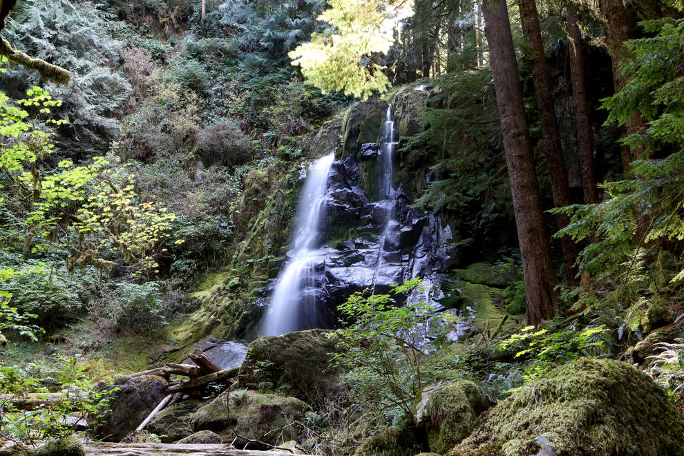
Upper Kentucky Falls is less than a mile from the trailhead; the lower falls are another 1.4 miles. (Collin Andrew/The Register-Guard)
It’s no surprise that the Cascade Range, to the east of Eugene, is full of dramatic, splashy waterfalls. But heading out west, to the Coast Range, reveals some hikes that are not as steep but just as scenic as their Cascadian cousins.
Because these destinations are not as high up on mountainsides as some of the well-known Cascade Range hikes, they are typically more easily walkable for all ages and are no less spectacular.
These three hiking and sightseeing destinations — Alsea Falls/Green Peak Falls, Sweet Creek Falls and the less well-known Kentucky Falls — offer some of the West’s best waterfall trails.
Alsea Falls/Green Peak Falls
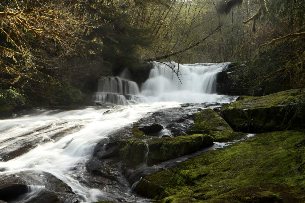
The 20-foot tiered falls are moments from the parking area at Alsea Falls Recreation Site; a 1.2-mile loop trail reaches the nearby campground. Green Peak Falls is 2.8-mile round trip from here. (Collin Andrew/The Register-Guard)
This destination is a two-for-one, if you feel like going about the same distance twice to reach the less-visited Green Peak Falls once you’ve admired Alsea Falls. Alsea Falls is located within the Alsea Falls Recreation Site, which includes a campground and picnic area that is open from May 1 into the fall.
The trail follows an easy, flat 1.2-mile loop to the campground bridge or a slightly more uphill 2.8 miles to the 60-foot Green Peak Falls. The Alsea River is generally peaceful except when it plunges 20 feet from one ledge to the ledge below. Water ouzels, or American dippers — those acrobatic birds that dunk themselves entirely in the water to feed from the rocky bottom — are easy to spot here. When the water is low, the pool at the bottom of Alsea Falls becomes a popular swimming hole.
Green Peak Falls is located within Hubert K. McBee Memorial Park, a picnic area owned by the Hull-Oakes Lumber Co. — a family-owned mill that is one of the last commercial steam-driven mills in the country.
Getting there: From Junction City, travel north on Highway 99 W. Just after the town of Monroe, turn west at a sign pointing to the town of Alpine, then follow the signs for Alsea Falls for about 13 miles until you reach the picnic area entrance. There is room to park close to the trail at the far end of the loop.
More information: Salem District BLM, 503-375-5646; rgne.ws/1P3JXL4
The 20-foot tiered falls are moments from the parking area at Alsea Falls Recreation Site; a 1.2-mile loop trail reaches the nearby campground. Green Peak Falls is 2.8-mile round trip from here. (Collin Andrew/The Register-Guard)
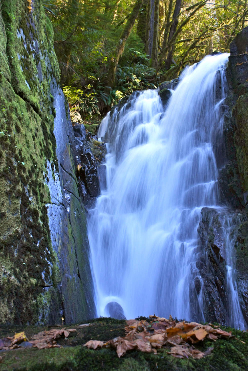
This trail got its name from the Sweet pioneer family that settled here in the late 1800s, but it also tops the list as a “sweet” place for a hike with children. The hike is a level 2.2 miles, but what makes it special is that the creek meanders over so many rock ledges that you’re seeing mini waterfalls along the entire route, unlike other destinations where you don’t get any payoff until the end.
The water falls in four distinct plunges ranging from 10 to 30 feet over this short distance, but kids will count many more spots where the water drops. Children also will love the wooden walkways that hug the side of the mountain and the catwalk bridge suspended about 15 feet over the water.
In the late summer if there hasn’t been significant rain, the water level is diminished enough that some parts of the creek are shallow and warm enough for wading. You don’t have to be a kid to love this hike — it’s easy, accessible, scenic and fun, and a great place for a picnic.
Getting there: From Eugene, take Highway 126 west to Mapleton. Leave the highway just before the Siuslaw River Bridge crosses into Mapleton and go south on Sweet Creek Road for slightly more than 10 miles to the first trailhead. Parking lots are available at each trailhead.
More information: Siuslaw National Forest, Central Coast Ranger District, 541-563-8400; rgne.ws/1I8NkP2
Kentucky Falls
Less well-known than the other two is Kentucky Falls, an easy hike — albeit reachable only by a more circuitous drive — that offers three waterfalls for the effort of one. Within less than a mile of hiking, you’ll be treated to a clear view of Upper Kentucky Falls. In another 1.4 miles, the trail ends at a small wooden observation deck that overlooks Lower Kentucky Falls. Here, the river splits into twin falls that drop 100 feet.
The trail is an easy 4.5 miles, but with an elevation loss of 800 feet on the way in, which means that coming back you might face some complaints about the climb if you went with little ones.
The trailhead also requires more specific directions to reach from the main road. Although the roads are marked, you need to know which ones to take because there are no signs indicating the falls.
The observation deck at the trail’s end is small, with only one bench, so there’s no room for a leisurely, spread-out picnic reward, but there are some magical moments on this trail that should make the slight climb back out worthwhile.
Less than a mile in is a tall, sheer rock face that echoes the sound of the water from the upper falls and seems to displace where it is coming from when you stand in front of it just so.
A little farther on is another rock face, this one moss covered and dripping with water, that a certain 7-year-old on the trail one recent day named “Drippy Falls.” When the sun hits it, Drippy Falls looks like liquid diamonds.
The trailhead is marked with a sign indicating that the area is home to a large population of mountain beaver, Aplodontia rufa. While it might not be easy to spot the critters themselves, it is easy to spot their handiwork. Their tunnels and dens can be seen all along the trail, under tree stumps and burrowing into the banks. The sign warns that they can tunnel under the trail, which may cause the trail surface to collapse.
Getting there: From Eugene, take Highway 126 west for 33 miles. Between mileposts 26 and 27, turn south at the “Whittaker Cr. Rec. Area” sign. In 1.6 miles, turn right across a bridge at another Whittaker Creek sign. Follow this road for 1.5 miles, then fork to the left onto Dunn Ridge Road. Continue for 7 miles to a T-shaped junction at the end of the pavement. Turn left on Knowles Creek Road and continue for 2.7 miles. Turn right onto Road 23. After 1.6 miles, turn right onto Road 919. After 2.8 miles, turn right into the parking area. The trailhead is about 50 yards from the parking area on the other side of the road.
More information: Siuslaw National Forest, Central Coast Ranger District, 541-563-8400; rgne.ws/19P4EK1
No comments yet.